
Reconstruction 11.2 (2011)
Return to Contents»
The Event in Miniature: 9/11 and the New York City Model / Marian Macken
Abstract: Many large cities offer their visitors and inhabitants two versions of the city to experience. There is the full-scale city, able to be walked around and become immersed within. Then there is the three-dimensional scale version, navigated differently, yet travelled over all the same. These city scale models document the urban situation, for viewers to understand the place within which the model resides. By modelling the city at a smaller scale, the city becomes graspable, its entirety able to be walked around, or in some cases, over.
City scale models represent the city in three dimensions. However, many spatial experiences and qualities of the city cannot be recorded in these models, hence highlighting the limits and specificity of this type of representation. The difficulty of representing the event of 9/11 in miniature is one such omission on the Panorama of the City of New York model; on this model, miniature Twin Towers still stand. The model portrays the city as a cohesive, designed whole: an idealised, unweathered metropolis with definite parameters. The city is seen to develop in staccato-like bursts, jumping from one static instant to another. This representation of surface, time and temporality defines these types of models. This essay uses the lens of architectural representation to read the 1:1 scale city, through the specifics of the event of 9/11.
Key words: Museums and archives, Urban studies, Visual culture
<1> Many large cities have modelled versions of themselves on display. These models offer a graspable, three-dimensional totality of the city. Depending on the frequency of updates, these models document the city unlike other representations. Although the city model is a static medium of envisioning space, it is this quality that offers a different reading of the city. The representation of time and temporality within the city model portray the city as a planned cohesive entity, which develops in short bursts from one static moment to another. The model of New York City offers a lens through which to examine the city of New York and the event of 9/11.
<2> The Panorama of the City of New York model The Panorama of the City of New York model, constructed for the 1964/65 World’s Fair, held in Flushing Meadow Corona Park, New York and now installed at the Queens Museum of Art (QMA), is an example of a model documenting an existing city [1] (Figure 1 and 2).

Figure 1. Lower Manhattan, with Battery Park and the World Trade Center in the foreground, looking northeast. (Miller 24). Photo: Dan Cornish/Esto.

Figure 2. The Panorama model of New York City, showing the Bronx, looking south toward Manhattan and Queens (Miller 23). Photo: Dan Cornish/Esto.
Robert Moses, the 1964/65 New York World’s Fair Corporation president, conceived the idea for the model and hired the firm of Raymond Lester Associates to construct it, at a scale of one inch to one hundred feet, that is, 1:1200 scale.
<3> Moses, working in various city and state positions from the 1930s to the 1950s, was the man most responsible for shaping the physical structure of New York (Caro 5–21); it is perhaps appropriate then, that he orchestrated the model to be built of the city, as it records his influence on the city in representing so many of his projects [2]. Moses altered the shoreline of the city, built freeways, parks, bridges, public housing and civic buildings. Lewis Mumford writes that the influence of Moses on the cities of America was greater than that of any other person (qtd. in Caro 12). Moses highlighted the modernity, progress and development of the city by locating its skyscrapers and freeways on a scale model [3].
<4> Moses saw the role of the Panorama model as not just a tribute to the city, recording it as it stood at the time of building, but as a precise, permanent, and utilitarian planning tool, designed as a living model that would change and grow in response to the changes within the city it represents (Miller 3). Lester designed the model so that individual buildings could be easily removed, and roads and highways reworked without excessive cost (Miller 37). According to Marc H. Miller, Moses considered the model to be an ongoing resource for architectural firms, community groups, city agencies and others involved in the growth and management of New York City (36). The Panorama was to serve as an educational tool for school children as well [4]. The museum continues to strive to fulfil the goal of the Panorama being a "living model," changing and growing in response to the city itself (Miller 3). However, this intention being achieved is reliant upon the frequency of updates of the model.
<5> The model of the city of London, at New London Architecture, a permanent exhibition space dedicated to the future of the city’s architecture, has a similar intention (Figure 3).
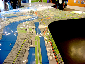
Figure 3. The model of the city of London, at New London Architecture, looking west, showing east London, docks and City Airport. (http://www.cityofsound.com/photos/new_london_architecture/docks.html)
This model is constantly updated, incorporating planned proposals within the representation of the existing fabric of the city. This model of London, at a scale of 1:1500, highlights forthcoming major developments that have received planning permission. Both the existing city is documented and its not yet existent intention. The model, therefore, becomes a strange pastiche of the city, being both how the city is, and how it may become. The model, in attempting to acknowledge the changing grain of the city, acknowledges the temporality of the city. The instability of the city is established, as within this context, the existing is read as that which may not always be there [5]. The London city model attempts to be both a record of the existing and a presentation of its future, achieved due to the frequency of its updates. When the updates are less frequent, the city is depicted differently.
<6> Other city models render the existing in various ways. In presentation models, used for highlighting a new proposal, the context of the existing city is often shown as neutral backdrop, to heighten the proposal’s impact. Often this is achieved by representing the city by white models, the intention being to show new work within an existing fabric’s form [6]. In these types of models, the existing city is made of one material, one colour and monolithic, in contrast to the colour and materiality of the proposal.
<7> This method of modelling can reduce architecture to volume and geometry, and suggest knowledge through an omission of information (Mack 208). Jeremy Levensohn writes:
As a sales and promotional tool for developers, architects, and urban planners, models represent projects in their idealized state, often in a manipulated context or out of context altogether. The model offers us a Gulliver’s view of a Lilliputian world, its seduction of scale reinforcing the sense of our powers to control the environment, whether it be unbroken countryside, a city block or the interior of a room (qtd. in Busch 27).
These presentation models take on an "ambassadorial role" (Moon 129). The city is seen in terms of aiding the perception of the proposed development.
<8> The city in these presentation models is backdrop, providing separation from the focus of the proposal. The site’s boundaries are emphasised, with new relationships extending from those boundaries not shown. These models are not within a context of time passing, they are a moment’s imagining of a proposal. The Panorama model has length of time associated with it, existing through decades of the city. But its presence is influenced by the frequency of its updates.
<9> The updates of the Panorama model The updates of the Panorama model of New York City have been sporadic, and so proposed developments are often excluded from it, and only completed projects are modelled. The Panorama model had complete updates in 1967, 1968, 1969, 1974 and then, after an eighteen year hiatus, in 1992, when 65,000 buildings were replaced [7]. In 2007, the model had a lighting upgrade, including spotlights, a virtual sunrise every hour and the addition of an audio component [Kilgannon]. Ideally, as buildings were constructed, the QMA hoped that architects and developers would donate models to be included on the Panorama model. However, the rising price of construction of the full-scale version of the building often prevented these contributions.
<10> As it stands in 2010, the Panorama model includes every building constructed before 1992 in all five boroughs [8]; it is a snapshot of a city eighteen years ago. When an update is completed, the model undergoes a dramatic change, then in the space of time until the next update, the model enters a hiatus; it becomes outdated the day after the upgrade is completed. A recent event in New York’s history highlights this situation: the Panorama model has not yet incorporated the post-9/11 landscape of the city.
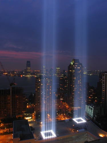
<11> After the World Trade Center was destroyed on 11 September 2001, twin rays from eighty-eight search-lights in downtown Manhattan, echoing the columns of the Twin Towers, illuminated the night sky for a month after the attacks [9]. This temporary artistic gesture, serving as a monument to those who died in the incident, has become an annual event in New York, mounted each anniversary since, from dusk until dawn (Figure 4).
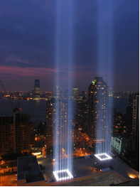
Figure 4. Tribute in Light: twin rays symbolising the World Trade Center towers destroyed on September 11, 2001, illuminate the sky over Manhattan. (http://farm2.static.flickr.com/1250/1363285668_a43b3293de.jpg)
<12> For the first anniversary of the event, in 2002, the World Trade Center towers were removed from the Panorama model, and replaced with a version of the Tribute in Light, using lasers to simulate the search lights (Figure 5).

Figure 5. Tribute in Light on the Panorama model, 2002. (http://gothamist.com/archives/2003/11/11/tribute_to_light_in_the_panorama_of_the_city.php)
This poignant event in the history of the model, almost mirroring, or re-enacting the original event was created by the artists responsible for the original Tribute in Light, Julian LaVerdiere and Paul Myoda. However, in researching a permanent solution, it was discovered that the lasers needed either a thin mist of moisture or some sort of particulate, such as dust, off which the light could reflect (Strauss). Either of these options would be detrimental to the model, and hence the Tribute in Light was installed on the Panorama model for only one day. The next day, the Twin Towers were reinstalled and have remained on the model since. Once the new development for the site is built, the museum intends to replace the towers with its miniature version. The towers will then be put in a special display with artists’ responses to 9/11 [10].
<13> In addition to this, the museum temporarily placed a commemorative ribbon and spotlight on the towers, and provided two tall explanatory panels [11] (Figure 6).
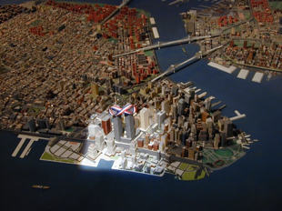
Figure 6. Commemorative ribbon and spotlight on the World Trade Centre, Panorama model. (Photo: Prof. Barbara Kirshenblatt-Gimblett, New York University.)
The small metal plane which takes off from LaGuardia Airport, flies a short distance and then lands, as a continuous loop, was removed before 9/11 to be repaired, but was not replaced for some time (Saunders). Blagovesta Momchedjikova writes that therefore "the Panorama was transformed from a model into a memorial, from history into heritage" [12].
<14> According to David Strauss, the former Director of Public Relations and Marketing at the QMA, the museum has been debating the issue of the presence of the Twin Towers on the model (Strauss). The model, as it exists, is an historically accurate depiction of New York City in 1992. Removing the towers for one day, then reinstating them, had the effect of returning the city to its before-the-event phase. Although their presence on the model now represents a falsehood, they allude to the factual historical literalness of the model. In becoming an historical record of New York City some eighteen years ago, the model becomes a "before" version of the full-scale’s scarred "after."
<15> The limits of these city models in representing certain spatial experiences and qualities of the city allow another version of the city to be shown. The event of 9/11 highlights this. The presence of Ground Zero, as the site of the former World Trade Center is now known, in the psyche of the residents of New York is strong. The absence of two important buildings on the fabric of Manhattan is a definite phase of the city’s history, yet this absence is excluded from the model of this city. But the qualities of the site of Ground Zero allude to more than the absence of the Twin Towers: they refer to how the buildings fell. Adjoining properties were affected by debris and deterioration, and the site below ground was exposed, creating a hole that has connotations of the void. It was not a clean, City-initiated demolition. Rather, the site suggests the magnitude and nature of the violence of the buildings’ removal. The Panorama model, in contrast, was actually designed to allow for an easy removal of buildings. There is no distinction made on the model, therefore, between differences in the disappearances of buildings.
<16> A slurry wall at Ground Zero, constructed on bedrock foundations and designed to hold back the Hudson River, survived the events of 9/11. Studio Daniel Libeskind’s masterplan proposes that portions of this wall be left exposed, as visitors journey ten meters below ground to a memorial called Reflecting Absence [13]. Libeskind sees the presence of the wall as demonstrating the monumentality of New York after a terrorist attack. The power of the act of the removal of the Twin Towers to reveal such an element of the site cannot be replicated as a modelmaking act: the existing bedrock that has been exposed will have to be replicated in model form and "added on." A model does not replicate a scale version of the underlying foundations of a building, hence the notion of the ground plane exposing through scarring is lost with this method of representation.
<17> Visible ruins at Ground Zero allow the spectator to reconstruct the buildings by imaginative effort, by offering negative space. When the proposed development for the site is finalised and built, and, hence, replicated at scale on the Panorama model, there will be no evidence of that which it replaces. The hiatus of the emptiness of Ground Zero will never have been represented, nor will the palimpsest of collective memory of the city of such an event.
<18> The temporality of city models In order to highlight the specificity of these types of city models, their limits need to be addressed. That which cannot be represented or documented on a model highlights the representation of time and temporality that are shown, specific to these types of models. The representation of time, in rendering the city as staccato-like in its development, is particular to the city model. In representing the temporality of the city as a series of frozen moments, the model also offers the potential to view the city differently from its full-scale version.
<19> The half-built, the untended and unintentional, the falling down and decaying buildings are not represented in a model such as the Panorama. The exclusion from the model of other events in New York’s history assists in indicating this. In the mid-1960s to the mid-1970s a wave of arson attacks destroyed nearly half the buildings in South Bronx. Yet such a transformation of decay to a neighbourhood is not represented on the model.
<20> On the Panorama model, an empty building looks the same as that which is occupied. These types of models cannot show time and use, or the age and decay and weathering that the city and its buildings experience, in other words, how space changes over time. Akiko Busch has written of this general quality of models, that the buildings are "stilled, pristine. They bear no vestiges of time and weather. They are untouched by the gritty substances of urban life" (27). Busch concludes that it is the nature of models to remove architecture from its context. However, beyond exclusions of aging, wear, and inhabitancy, city models are in fact able to depict other qualities of the city, and, hence, other and at times more subtle contexts. By referring to another exclusion from the city model in reference to 9/11, this may be explored in more depth.
Terrain vague and the city model
<21> Ignasi de Solà-Morales Rubió writes of the empty, abandoned space within a city, in which a series of occurrences have taken place (118–123). He denotes these spaces by the French expression terrain vague. He defines the term terrain as connoting a more urban quality than the English word "land"; terrain refers to "the physical idea of a portion of land in its potentially exploitable state but already possessing some definition to which we are external" (119). The French vague has come to mean empty and unoccupied yet also free, available and unengaged. According to Solà-Morales Rubió, it is the relationship between the absence of use and activity with a sense of freedom and expectancy, a void coupled with latent possibility, that is fundamental to understanding the evocative potential of the city’s terrains vagues (119–120). Soon after the event of 9/11, Ground Zero became an area of terrain vague within the city of New York. It adhered to Solà-Morales Rubió’s definition of a tract of land that is unoccupied yet has latent possibilities.
<22> The inherent indefiniteness, instability and fluctuation of these types of spaces are not conducive to precise architectural representations. According to Solà-Morales Rubió, terrains vagues seem to command the eye of the modern photographer, who has captured the condition of these spaces as internal to the city yet external to its use. In other representations, however, these spaces are absent.
<23> Solà-Morales Rubió’s essay entitled "Terrain Vague" is concerned with how architecture can act in the terrain vague without becoming an "aggressive instrument of power and abstract reason" (123). The individual, he reasons, looks for forces rather than forms, yet architecture’s destiny is concerned with colonisation, and the imposing of limits, order and form, that is, an instrument of organization, rationalism and productive efficiency. This then results in the desire to transform the fallow into the productive, the void into the built, that is, the violent transformation of estrangement into citizenship in the name of efficacy [14]. The same could be said of the aim of architecture’s representation: with this concept of architecture, "blank" spaces do not model well.
<24> The white space within a drawing may be interpreted as sparseness, or as the manifestation of the drawing’s abstraction. The Panorama model, however, does not have an analogy for such white space. Australian landscape architect Kirsten Bauer has investigated spaces of terrain vague, and their representation. According to Bauer, "absence" as a design strategy needs the deliberate use of an already abstracting representation, an in-built void mechanism, that allows a strategic editing of information, of "things" (28). Bauer refers to these graphics, that eradicate processes from their representation, as "smoothing over" graphics. Maps within street directories are just such a graphic, she argues, with the white areas the undetermined areas. She reasons that such media allow the "absence" within terrain vague sites to stay within the design process, rather than "loading" the site with an additive accumulation.
<25> City models however, ask for seamless, designed areas. The undesigned is hard to document, with the exception of "nature." Terrains vagues are often represented as examples of a "before/after": identified as areas that should be "filled in" with a "better" version [15]. This is the treatment Ground Zero will have on the Panorama model: the 1992 "before" version and then the post-development "after" version. In omitting a site’s fallow time, the city maintains cohesion. By the World Trade Center remaining on the model, the legacy of a unified urbanscape is maintained. The city’s present relationships with Ground Zero are overlooked, with the emphasis on the city as a developed entity rather than the city’s phases between development.
<26> The limits of representation inherent within the Panorama model insist that it exclude the temporary, the changing and the indeterminate, in addition to the terrain vague. The Panorama model does not represent demolition, dereliction, ruin or incompleteness. Hence, the city is represented in a particular way and the viewers’ perception of the city is one of a planned, designed destiny. Each city block has a definite parameter, every square meter seems to be accounted for and determined. All the buildings are "completed," so the city has a "finished" look. Due to its objecthood, the model of a city has a sense of closure to it. The Panorama model demands design and intention, as this is what it models.
<27> Due to these limitations of representation specific to the model, the event is able to be represented in another way. Combined with the intended strategy of the QMA not to model Ground Zero or the as yet unbuilt proposal (Strauss), the events of 9/11 will therefore be represented by a sequence of states of the Panorama model: as the city is in 1992; the one-day Tribute in Light version; and the post-development form. Therefore, the event is represented by the modelling of each of these phases, that is, the city’s development is represented by a succession of models.
<28> The model city, therefore, is in stasis, between each update. However, by modelling the city as a static form allows it to become part of a series, like a set of animation stills. This series of stills then begins to depict movement, similar to the film editing device of the jump cut [16]. The discontinuity displayed in this type of representation serves to accelerate the movement of the city, and highlights the unreality of the model experience, rather than its narrative ability. The jump cut, within film editing, confronts traditional continuity conventions. By emphasising the cuts within a sequence it alludes to the notion of film being cut up bits of imagery, rather than trying to present the film’s content by way of "invisible" editing (Fairservice 313). In the same way, the Panorama model, does not represent time passing in an "invisible" seamless way, but rather unconcealed in a fragmented structure.
<29> This device may be used photographically, by taking an image of the city from the same place over a number of years, and then adding them together in a flip book to create a continuous animation. However, unlike a sequence of photographs or a series of film frames, the model does not get remade each time, to sit next to its earlier version. Rather, the next phase of the model is latent within the model itself. The city does not identify where likely alterations will be, it does not record the city as a site for change. In this way, the model and the city operate similarly. The 1992 model version of the city cannot hint at the instability inherent within the miniature skyscrapers at the tip of downtown Manhattan.
<30> Due to its objecthood, the Panorama model operates on two time scales. The first time scale compresses time, similar to photographs taken over many years and collated to form a series. These create movement within the city by compressing time. Also, in displaying a day-night cycle, that allows night to fall every three minutes, the model compresses time. This is similar to the models of artist Callum Morton. His work explores the event space of models, including the ephemeral life within known architecture. In his work "Habitat" (2003), he models the housing complex in Montreal by Moshe Safdie. Accompanying the model is a 28-minute sequence of changing lights and sounds, a compressed version of the day, yet giving a sense of duration and time passing.
<31> The Panorama model, however, also represents the city at a real time scale: the changes can only be made when the 1:1 scale version of the city has sufficiently changed. Then it must be static until the city is sufficiently altered to warrant another upgrade. It is an editing jump cut in real time. In this way, the Panorama model maintains its object status, and the original city is implicit within each subsequent version.
<32> In representing the city at an instant, and then, after another update, jumping to another instant, renders the city both finished and suspended in time. It is this particular quality of models, that is, representing time as a series of moments, that contributes to the specificity of models. This offers an alternative to the predominance of photography as the dominant visual experience of the city. The city model is different from the manipulative composition and framing of architecture that the privilege of photography offers. The gaze is not constructed by the camera’s composition. The ability for photographs to be reproduced removes the emphasis of the power of the original. The Panorama model, by remaining present throughout each upgrade, maintains its objecthood. At a city scale, there is a quiescence to the model. Rather than attempting to capture the flurry within urbanity, these city models present the city as stilled, inert and dormant. In representing the city in this way, a lull is provided, fostering a steadiness of gaze: a pause is created, within which to examine the city. In the case of New York, this is a public space to contemplate the event of 9/11, different from the 1:1 version of standing at Ground Zero. Novelist Lionel Shriver writes of this notion of pause within the city, in reference to a character’s reaction to 9/11:
For she ordinarily took for granted the architecture of her personal life, even more so did she take for granted the literal architecture of the city from which she hailed. Granted, history lends itself to the conclusion that pause is rare, that any respite is as merciful as it’s bound to be brief, that the very nature of existence is unstable and it is therefore best to be prepared for just about any catastrophe lurking right around the corner on any arbitrary morning. Thus the only real surprise should be those single sunny awakenings on which there is no surprise (Shriver 448).
It is in this examination of the city, the act of gazing at the model as object, that identifies further specificity of the city model and possible relationships to other representations.
The objecthood of the city model
<33> The physical size of city models involves issues of how the viewer moves around, or over them in order to view their enormity (Figure 7).

Figure 7. The Futurama model, at the 1939 World’s Fair, showing visitors viewing the Futurama from moving seats, at the General Motors’ Pavilion. c. 1939. (Miller 33).
To view the Panorama model during the World’s Fair, visitors took an eight-minute sky-ride, during which visitors slowly circled its over 150 meter periphery in railcars and listened to Lowell Thomas’s recorded narration. Billed as a "helicopter trip" around the city, the ride simulated views from 90 to 600 meters [17]. Such a vantage point is unusual for any visitor to a city. It accentuates the scale differences between the city and its model, and heightens the graspable nature of the model. Morris writes that the miniature offers "instant totality"; the city is able to be grasped not by breaking it down into parts, but seeing the whole (Morris 11). Adnan Morshed, in describing the aerial viewing technique of the Futurama model at the 1939 New York World’s Fair, writes that this view reveals the presence of early twentieth century modernist visuality (77). Morshed uses the term "aesthetics of ascension" to describe the modernist logic that if the viewer saw the total picture, with all its linkages and relationships, then a new understanding of ordering and disciplining the picture could occur (77). The model’s spectator, therefore, was capable of reaching both the literal and conceptual vantage from which to envision utopia (Morshed 78).
<34> One’s enchantment with the miniature stems from the sense of power that it instils in the viewer (Busch 11) [18]. Since it is easily manoeuvred and manipulated, the miniature grants the viewer a sense of authority. The city model emphasises the inhabitants’ control of the city: the city can be made, and is there for the making and remaking. Thus when the miniature is observed, the viewer is engaged in a private closeness, leading to an implicit intimacy with the city (Busch 11). At the same time, models create the viewer as a giant, leading to exclusion and distance (Stewart 70). The city model, then, while allowing the viewer to read the city in an intimate way, also excludes the viewer from the experience of being within the city. Yet this distance provides a reading of the model that creates similarities with other forms of representation.
<35> In making the city comprehensible, this view of the city is different from the one most experience, either walking within it or viewing it through a window. Susan Stewart has written that such a view is "within a definite frame and limited perspective, mediated and refracted through the glass of the city’s abstraction of experience" (79). This view from above, as one experiences viewing a model, "remains a view from elsewhere, a view which in making the city other must correspondingly employ metaphors of otherness" (Stewart 79). Hence, the city model is removed from the city inhabitant’s experience, yet in existing as such, the city model offers the representation of that which is familiar to the inhabitant of the city, or that which is becoming familiar, to the visitor. Viewing the miniature city, within that city itself, offers the opportunity for a reflection on the familiar. A similar idea is offered by the novelist Margaret Atwood, who has written that maps "contain the ground that contains them" (557) [19]. City models also contain the ground that contains them; the viewer is able to trace their journey to visit the model, on the model itself.
<36> This situation allows a relationship between the city’s model and its maps to develop. Robert Harbison writes that from cities in the physical realm to cities on maps is a path of increasing conceptualisation (124–39). However, to turn the map upside down changes this pure conceptualisation into an illusion, a picture. The view is just as authentic yet its meanings have shifted. According to Harbison, the map operates by reinforcing the sense of where the viewer is, in relation to all else, as though the viewer is always standing like a statue, facing the same way [20]. City models, having the ability to be walked around, do not have a map’s "top" and "bottom" to their reading, as Harbison describes. However, models exist in relation to their symbiotic city maps, which are no doubt more familiar to the viewer. Hence, the model is perhaps read with the same orientation in mind as its map, with north pointing "upwards." Maps, therefore, have a strong relationship to the city model and become the mediator between the city and its model.
<37> Harbison writes that since the system of roads is often emphasised, maps may be seen as documenting the paths of routes taken [21]. But while documenting the familiar, maps must also contain the unknown, for them to be interesting to "read" [22]. As a city becomes more familiar, this balance of the known with the unknown shifts, and one’s relationship with the map of the city is the proof of this: "maps of places becoming familiar are records of learning and proving grounds for it" (Harbinson 133). One gains a certain map knowledge. City models operate similarly, and one gains a model knowledge. This comes about by living within the city and travelling within it. Therefore, the place is thought of mainly as a surface (Harbinson 128).
<38> The familiarity that the Panorama model elicits within viewers results in the model gaining a presence in itself. It has become the city’s metaphor. In the 1970s, an advertisement appeared, with a woman sweeping the Panorama with a broom, to promote a "Keep New York Clean" campaign (Miller 43) (Figure 8).

Figure 8. Photograph taken on the Panorama for an "I Love a Clean New York" advertisement. c. 1970. (Miller 43).
New York City Mayor Edward I. Koch once used the Panorama to trace the route of the New York marathon in a television promotion, emphasising the notion of the viewer travelling over the surface of the representation (Miller 41).
<39> The model, therefore, develops a relationship with its containment: both with the QMA and with the city itself. This is demonstrated in the work of the members of Flux Factory, an artists’ collective in Queens, New York who occupied the museum daily for three months, in order to create an in situ work for the Queens International exhibition. On day eighty-eight, they discovered how to get under and onto the Panorama [23]. Onto the Panorama, Jean Barberis placed a model, by one of the artists John Norwood, on the spot in Queens where Norwood has his studio. In the act of placing this new building, Barberis spontaneously took one of the modeled boats from the Hudson River. That evening as they drove to the West Side of upper Manhattan, a video was taken of the boat traversing the streets and bridges along the way. The boat is then returned to the actual Hudson River, at about the spot where it was removed from the model. On the side of it Barberis wrote "If found, please return to the Queens Museum of Art" [24]. The Panorama exists within the 1:1 city, and by this act, is released into that city.
<40> The representation of the city as surface is reinforced by the depiction, on the Panorama model, of the city as a seamless, designed entity. When represented as a surface, the city is seen as possessing a holistic organisational pattern. The wordlessness of models, compared to a map’s evocative, unfamiliar placenames, promotes the search for the familiar [25]. According to Harbison, the prominence of roads on maps alludes to journeys, and so the viewer of the map is involved in an imaginary traversing over the page. This places the maps’ context within that of future travel and, hence, foreignness. Maps may reside folded in a drawer, with disparate cities sitting on top of one other. The Panorama model needs no unfurling, and it is viewed within the city it depicts, that is, the full-scale holds the miniature within it. Hence, the gaze of the viewer is encouraged to travel over the model, similar to one’s journey over the city. Therefore, the city, represented in this way, is read as the place over whose surface one traverses. The static representation of the city has within it the potential motion of the viewer.
<41> The difficulty of representing the event of 9/11 on the Panorama of the City of New York model highlights the particularites of the three-dimensional city model, which reflects back on the city it resides within. Rather than representing the hiatus of the emptiness of Ground Zero, the model is read as depicting a scenario of the city which came before that which exists in the full-scale city. When the proposed development for the site is finalised and built, and, hence, replicated at scale on the Panorama model, there will be no evidence of the years of absence that inhabited the site. The city, seen to develop in short bursts, is represented as a series of moments in a sequence of the model. Between each update of the model, the miniature city is in stasis, stilled in this pause that the model offers.
<42> An examination of the particular representation of the city in model form offers an alternate view of the event of 9/11 and hence, a broader discussion of the inhabitants’ grasp of their city. The limits of representation of the Panorama model, in not yet incorporating the post-9/11 landscape of the city, insist that it exclude the temporary, the changing and the indeterminate, in addition to the terrain vague. The representation of the temporality of the city does not allow for sites of demolition, dereliction, ruin or incompleteness. Instead, the city model renders the city as a seamless entity, without fallow sites. The city is portrayed as a cohesive, designed whole: an idealised, unweathered metropolis with definite parameters. Hence, the city is perceived as having a planned, designed destiny. The Panorama model offers a site for reflection on the city of New York. This is not a neutral documentation, but a representation that offers an alternate view of the city, and one that influences designs for the architecture of the city.
Endnotes
[1] Using aerial photographs, street maps and photographs of individual buildings, a team of one hundred people constructed it in 273 sections. At the time of its creation, it was called the "World’s largest scale model", and to this day, it is still the largest architectural model of an urban environment (Momchedjikova qtd. in Ballon 310). It occupies 9,335 square feet. The base is made of urethane foam mounted on Formica flakeboard framed by pine boards. The buildings are made of wood and plastic, the 35 major bridges are brass, shaped by a unique chemical milling process. Windows are not accurately portrayed on the model, relying instead on standardized stencils. The model took over three years to build, and finally cost US$672,662.69, in 1964. The Panorama was expected to accurately duplicate the topography of the New York City area landscape, as well as the exact placement and appearance of all human-made structures. The contract allowed for only a 1 per cent margin of error. Due to size restrictions, the section showing Far Rockaway was never installed (Miller 29, 46).
[2] In his construction of public works, Moses used architectural models as aids in both the planning and promotion of projects. In some ways, the Panorama model is a documentation of Robert Moses’ projects, as these are emphasised in the making of it: the bridges, seven of which he had constructed, are the only elements in metal. Parks, another of Moses’ interests, are emphasised by the unique device of painting them in an ultra-violet green so they glow through the night cycle (Miller 8, 10, 39).
[3] The 1939 New York World’s Fair presented the future as an animated model of an American utopia, as it might appear in the year 1960. The next New York World’s Fair presented the city as built, as its version of modernity.
[4] During the 1988/89 school year, 26,000 elementary and high school students visited it (Miller 41).
[5] According to Deyan Sudjic, this model reduces a metropolis to a tabletop train set, turning the development process into a spectacle in an attempt to send a political message about the dynamism, far-sightedness and competency of the planners involved. However, according to Sudjic, it is difficult for the viewer to react with anything but "quiet, fascinated awe." He writes that it therefore sits between Stalinist instruments of propaganda and doll’s houses, mixing the sinister and the winsome (Sudjic).
[6] Moon writes of the lineage of white models, particularly from plaster models in the nineteenth century; in the twentieth century, many modernists found this to be sympathetic to their aims (Moon 129).
[7] In 1989, Abby Bussel wrote, towards the end of that hiatus, that the model was 20,000 buildings behind the times (21). Miller has written that a side effect of the piecemeal fashion in which the Panorama is being updated, is a breakdown in the uniformity of the model’s look (43).
[8] That is, 895,000 buildings. According to Miller, in 1964, the number of buildings was 830,000. The Empire State Building was the largest building in New York City at the time the Panorama was constructed (46). According to David Strauss, current Director of External Affairs, there have been some minor updates recently, including the stadium CitiField and Battery Park City. The QMA hopes that the updates will be ongoing, funded by their new "Adopt-a-building" fundraising initiative (Strauss 2010).
[9] Tribute in Light was conceived by architects John Bennett and Gustavo Bonevardi of PROUN Space Studio, architect Richard Nash Gould, and lighting designer Paul Marantz. Productions support was from the Municipal Art Society and CreativeTime, with the assistance of Battery Park City Authority. These lights, on clear nights, can be seen for over 60 miles (Tribute).
[10] When the Museum removes buildings from the model, most are kept in the Museum’s archive or used for educational purposes, such as helping blind museum goers understand the scale of the Panorama (Strauss). The potency of the actual buildings of the World Trade Center has been acknowledged in model form in a project by Douglas Coupland. He included the Twin Towers, with no context, as part of his Super City installation at the Canadian Center for Architecture. They are shown without their city, painted white, echoing his recollection as a child that everything in the Lego universe was perfect and crisp and antideath (Super City).
[11] These were added a week after the first anniversary of 9/11, and were removed in the summer of 2005 (Momchedjikova n.p.).
[12] Momchedjikova cites Barbara Kirshenblatt-Gimblett’s Destination Culture: Tourism, Museums and Heritage in this notion (Momchedjikova n.p.).
[13] This memorial, the result of an international competition, is to create a quiet, mediative, spiritual space. It is due to be completed in 2013; collaborating architects are Michael Arad and Peter Walker (Studio Daniel Libeskind).
[14] Solà-Morales Rubió goes on: "When architecture and urban design project their desire onto a vacant space, a terrain vague, they seem incapable of doing anything other than introducing violent transformations, changing estrangement into citizenship, and striving at all costs to dissolve the uncontaminated magic of the obsolete in the realism of the efficacy. To employ a terminology current in the aesthetics underlying Gilles Deleuze’s thinking, architecture is forever on the side of forms, of the distant, of the optical and the figurative, while the divided individual of the contemporary city looks for forces instead of forms, for the incorporated instead of the distant, for the haptic instead of the optic, the rhizomatic instead of the figurative" (122–123). Elizabeth Meyer outlines the notion that landscape is defined by what architecture is not, landscape having no order other than the complement to architecture. The goal, she writes, "is to allow landscape architecture to speak, to articulate a language which eschews binaries and operates in the spaces between the boundaries of culture and nature, man and woman, architecture and landscape" (13–34).
[15] This idea is reiterated in a comment by Leon van Schaik, cited by Peter Connolly in his response to Solà-Morales Rubió’s essay. Van Schaik was referring to a number of recent landscape architectural competition entries: "Landscape architects tend to want to fill up their designs and sites with all manner of ‘things’ … as if the competition sites were lacking something, or that no-thing is there until some-thing is put there." (Connolly 23).
[16] This technique was used most notably by Jean-Luc Godard, as part of the French New Wave cinema, where the middle section of a continuous shot is removed and the beginning and the end are joined together. This break in the continuity of time produces an effect in which moving objects appear to jump to a new position.
[17] This is similar to the technique of viewing the Futurama model at the 1939 New York World’s Fair. This was an eighteen-minute ride on a suspended, winding conveyor belt that simulated the experience of flight. According to Adnan Morshed, "how the future was seen had become as appealing as what was seen in it" (77). The Panorama sky-ride was replaced in the early 1990s, by New York City-based architect Rafael Viñoly, with a sky-walk around the periphery (Ballon 310).
[18] Bel Geddes, when working on the Futurama project, wrote of the quasi-divine experience of "walking around with pockets and hands full of skyscrapers" (Morshed 89).
[19] Equally, on the Panorama is a version of the QMA itself, and "as your gaze sweeps across the whole of the city it can pause at the museum and watch itself in a moment of solipsism" (Meis 65).
[20] Harbison elaborates: "Maps sedulously reinforce and protect our sense of where we are, a sense which can be very elaborate without being deliberately worked out, and which we can derange artificiality by obliterating the reference point east or west to which we habitually look" (124).
[21] An analogy between maps and models is possible: "Maps simplify the world somewhat in the way a heavy snowfall does, give the sense of starting over, clarify for those overstimulated by the ordinary confusion. Each path in the snow shows, the ground keeps a record but also makes one feel there is a manageable amount going on." (Harbison 127).
[22] "All maps are abbreviated places … The better we know a place the less we want it reduced, because to stay interesting a map must contain many things we do not know with some we do, and will bore us simply as a reminder … It is very satisfactory to see the little slice we know pillowed in the surrounding unknown. Though it might be diverting to have a map that materialized as we learned the places, we would miss the pleasure of keeping track of what we do not know." (Harbison 133).
[23] A "transgression of the highest order. If there is one thing at the museum that verges on the sacred it is the Panorama" (Meis 70). Six days earlier, the group entered themselves retroactively into history, by altering the circular model of the World’s Fair that sits just outside the entrance to the Panorama. Onto this they placed a modelled version of the Flux Factory pavilion (Meis 70).
[24] "At first the boat just bobs along. Then it catches a current and disappears north along the Hudson. Maybe one day it will be found" (Meis 71).
[25] Harbison compares the relationship of wordless photographs of the earth taken from the Gemini space capsule to maps, as being similar to the relationship of early photographs to painting, and show that maps are more than representation (125).
Works Cited
Atwood, Margaret. The Robber Bride. London: Virago Press, 1994.
Ballon, Hilary & Kenneth T. Jackson. Robert Moses and the Modern City: The Transformation of New York. New York: WW Norton & Co., 2007
Bauer, Kirsten. "Terrain Vague: A Melbourne Conversation." Kerb Journal of Landscape Architecture. 3 (1996): 28.
Busch, Akiko. The Art of the Architectural Model. New York: Design Press, 1991.
Bussel, Abby. "The City that Moses Built." Progressive Architecture. July, 1989: 21.
Caro, Robert A. The Power Broker: Robert Moses and the Fall of New York. New York: Vintage Books, 1975.
Clerkin, Paul. Super City – An Installation by Douglas Coupland: Canadian Center for Architecture, Montréal. Archiseek. 2005. Web. 5 June 2010.
Connolly, Peter. "T.V. Guide: Some Footnotes to Morales’s Notion of Terrain Vague." Kerb Journal of Landscape Architecture. 3 (1996): 23.
CreativeTime Inc. Tribute in Light. 2003. Web. 1 November 2006.
Fairservice, Don. Film Editing: History, Theory and Practice. Manchester: Manchester University Press, 2001.
Harbison, Robert. Eccentric Spaces. London: André Deutsch, 1977.
Kilgannon, Corey. "On the Town, Sized Down, Jazzed Up." The New York Times. 2 February 2007. Web. 15 August 2008.
Kirshenblatt-Gimblett, Barbara. Destination Culture: Tourism, Museums and Heritage. Berkeley: University of California Press, 1998.
Mack, Gerhard. Herzog and de Meuron 1978–88. Basel: Birkhäuser Verlag, 1997.
Meis, Morgan. "Devils Work: Secret Doings at the Queens Museum of Art." Harper’s Magazine. April, 2004: 65.
Meyers, Elizabeth. "Landscape Architecture as Modern Other and Postmodern Ground." The Culture of Landscape Architecture. Eds Harriet Edquist and Vanessa Bird. Melbourne: Edge Publishing Committee, 1994. p.
Miller, Marc H. The Panorama of New York City: A History of the World’s Largest Scale Model. New York: Queens Museum, 1990.
Momchedjikova, Blagovesta. "The Miniature Metropolis as Memory Palace." Diss. New York University, 2006.
Moon, Karen. Modeling Messages: The Architect and the Model. New York: Monacelli Press, 2005.
Morris, Mark. Models: Architecture and the Miniature. Great Britain: Wiley-Academy, 2006.
Morshed, Adnan. "The Aesthetics of Ascension in Norman Bel Geddes’s Futurama." Journal of Society of Architectural Historians. 63. 1 (March, 2004): 88.
Saunders, K. "Re: Panorama Model." Message to the author. 29 September 2007. E-mail.
Shriver, Lionel. The Post-birthday World. London: Fourth Estate, 2007.
Solà-Morales Rubió, Ignasi. "Terrain Vague." Anyplace. Ed. CC Davidson. Cambridge, Massachusetts: MIT Press, 1995. 118–123.
Stewart, Susan. On Longing: Narratives of the Miniature, the Gigantic, the Souvenir, the Collection. Durham: Duke University Press, 1993.
Strauss, David. "Re: Panorama Model." Message to the author. 26 October 2006; 8 June 2010. E-mail. Studio Daniel Libeskind.
Studio Daniel Libeskind. 2007. Web. 9 September 2007.
Sudjic, Deyan. "Metropolitan Lines." The Observer. July 17, 2005. Web. 2 February, 2009.
Return to Top»